

Last Updated at 10:25 am EST on Feb. 29th, 2024
NWS is starting to release their reports after the storms that rolled through Illinois, Michigan, Indiana, and Ohio. Above is the Storm Reports from February 27th and 28th. The count from spotters is 15 tornados in total. The total reported so far is 18. This Page will continue to be updated until 10:00 pm EST on February 29th.
Illinois Reports:
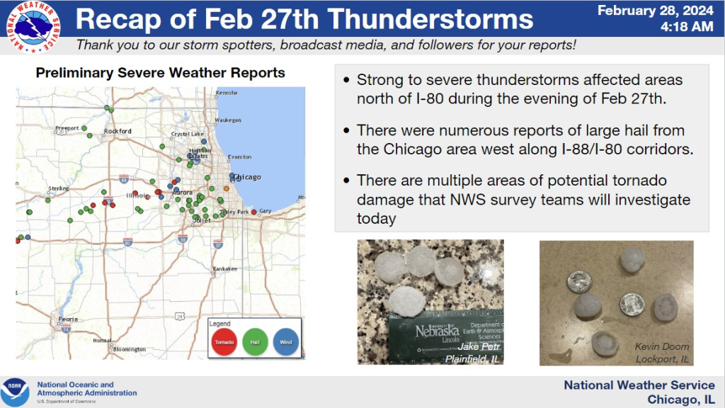
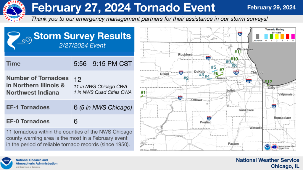
NWS Chicago issued multiple Severe Thunderstorm Warnings for large hail and damaging winds, with hail up to 2″ in diameter reported. Multiple Tornado Warnings were issued. Radar confirmed and/or suspected tornadoes occurred from northwest Illinois eastward to the Chicago suburbs. There were likely at least 5 tornadoes.
Chicago NWS
We are still waiting on the full report from Chicago NWS, but they have released a partial report.
Henry County:
An EF-1 Tornado was confirmed in Annawan, IL that stretched 2.83 miles and started around 5:56 pm CST (6:56 pm EST) on February 27th.
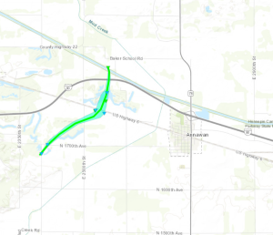
A high end EF1 tornado formed about 4 miles west of Annawan, IL at 556 PM. The tornado initially caused damage to tree limbs before intensifying as it approached Highway 6. At this point the tornado hit two homesteads causing damaging to siding and shingles at each homestead. One of the homesteads saw a shed destroyed. The tornado reached peak intensity just north of Highway 6, where a well constructed shop was destroyed by the tornado. This damage was rated at 110 MPH winds. The tornado then started to occlude and move more to the left as it crossed I80. A semi was flipped around I80 mile marker 31. A couple of branches were broken on the other side of I80. Around 604 PM,
Quad Cities, IA/IL NWS
The tornado dissipated just north of I80. The overall path was 2.8 miles and the max width of the tornado was around 425 yards.


Lake County:
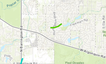
An EF-1 Tornado was confirmed in Mundelein, IL that stretched 0.1 miles and started around 8:55 pm CST (9:55 pm EST) on February 27th.
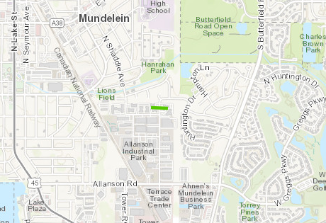
This tornado had a very short path with damage confined primarily to a single two-story apartment building. Most of the roof was removed from the building, and a portion of the brick facade also collapsed when the roof was removed. Two large softwood trees in the parking lot east of the building were uprooted. Debris was deposited to the east across the street, where a few tree branches were also snapped. In the apartment building south of the main one that was damaged, a resident described seeing a second story glass patio door on the east side being pulled out and shattered by the winds.
Chicago NWS
Cook County:
Cook County had the most tornados recorded during this storm with 3 total confirmed.
An EF-1 Tornado was confirmed in N. Hoffman Estates, IL that stretched 0.37 miles and started around 8:36 pm CST (9:36 pm EST) on February 27th.
A brief tornado touched down along Whispering Trails Drive on the north side of Hoffman Estates and moved northeast through a residential area. Two residences had a significant loss of roofing material, other homes in the neighborhood had more minor shingle damage, and a window was damaged at another residence. Minor tree damage, including broken limbs, was also observed. Roofing material removed from a home on Fir Court was deposited to the northwest, with plywood impaled into the ground and other debris penetrating the wall of a house, ending up in its living room.
Chicago NWS
An EF-0 Tornado was confirmed in South Barrington, IL that stretched 1.1 miles and started around 8:33 pm CST (9:33 pm EST) on February 27th.
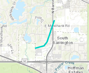
This tornado appeared to begin somewhere in the field to the west of the South Barrington Club, based on some scattered debris deposited in the field. It then struck the club, where it damaged a portion of the west wall and removed multiple sections of roof covering, depositing the debris in the treeline north of the club along Tennis Club Lane. It also snapped limbs and uprooted trees in the southeast portion of the neighborhood north of the club. Tree damage was also noted around the intersection of Mundhank Road and Barrington Road, where the tornado appeared to lift.
Chicago NWS
Another EF-0 Tornado was confirmed in S. Hoffman Estates, IL that stretched 0.75 miles and started around 8:32 pm CST (9:32 pm EST) on February 27th.
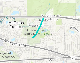
This brief tornado touched down in the area near Delta Drive and tracked northeast to Rosedale Lane before lifting as it reached I-90. Damage primarily consisted of snapped tree branches, downed power lines along Hassell Road, and damaged shingles, fascia, and gutters on homes.
Chicago NWS
DeKalb/Kane Counties:
An EF-0 Tornado was confirmed in Hinckley, IL that stretched 4.8 miles and started around 7:54 pm CST (8:54 pm EST) on February 27th.
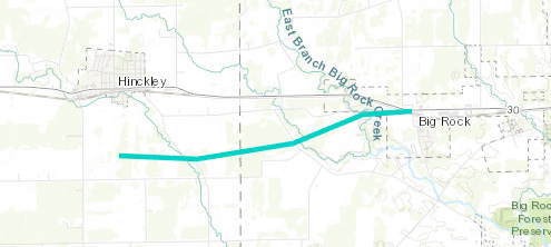
Storm chasers documented a tornado touching down in a field south of Hinckley between Somonauk Rd. and Sandwich Rd. north of Bastian Rd. The tornado caused damage to multiple farm outbuildings, peeled shingles off of roofs, and caused tree damage before lifting as it tracked into Big Rock.
Chicago NWS
DeKalb County:
An EF-0 Tornado was confirmed in Waterman, IL that stretched 0.25 miles and started around 7:30 pm CST (8:30 pm EST) on February 27th.
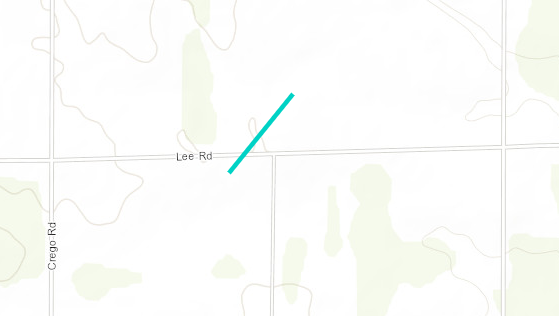
This tornado touched down in an open field south of Lee Road northeast of Waterman. It was on the ground for less than one minute and caused minor damage to a farmstead on the north side of the road before lifting.
Chicago NWS
Kane County:
An EF-1 Tornado was confirmed in Sugar Grove, IL that stretched 8.25 miles and started around 8:06 pm CST (9:06 pm EST) on February 27th.
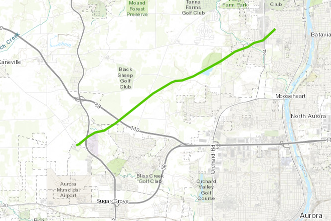
This tornado touched down near Hartner Road southwest of Waubonsee Community College. Damage to trees was noted as the tornado moved northeast toward IL-47. The tornado then moved through the Waubonsee Community College property with damage to trees, signs, and one large parking lot light pole, with a width of approximately 80 yards. Minor tree damage occurred at a farm along Bliss Road. The tornado widened to its peak width of approximately 125 yards as it neared two farms on Seavey Road near Lake Run. At one farm, multiple evergreen trees were snapped 5-10 feet above ground level. Across the road, a large wooden barn was pushed off its foundation and collapsed, with minor damage to the roof of a nearby grain silo and some nearby trees. The tornado continued to the northeast along Lake Run, causing minor tree damage. The tornado then narrowed and weakened as it neared Nelson Lake Road, with only minor tree damage noted. The tornado entered the southwest side of Batavia and moved through a residential area along Alberosky Way and Hapner Way, causing damage to shingles at multiple houses and several small branches, covering a width of approximately 100 yards. Damage to trees continued along Saupp Drive and Deerpath Road, with street signs damaged. The tornado then crossed Main Street near Deerpath Road, with damage to industrial equipment noted, along with some nearby minor tree damage. The tornado moved into a commercial area near Wilson Street and Randall Road, causing some damage to signs and the roof covering of strip malls. Sporadic tree damage was observed as the tornado continued to the northeast, and the tornado appeared to dissipate near McKee Street and Western Avenue.
Chicago NWS
An EF-1 Tornado was confirmed in Geneva, IL that stretched 1 mile and started around 8:17 pm CST (9:17 pm EST) on February 27th.
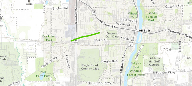
A tornado touched down along Keslinger Road west of Randall Road in Geneva. Trees and a traffic light were damaged as the tornado crossed the intersection, with shingle, soffit, and siding damage noted at a commercial building before the tornado moved into a residential area. A concentrated corridor of damage consistent with EF-1 wind speeds near 95 mph occurred along Cambridge Drive and Essex Court, where damage to shingles and windows was observed. Some nearby trees were significantly damaged with almost all large branches snapped. The tornado weakened and narrowed as it moved east just north of Kaneville Road, with minor tree damage noted until the tornado dissipated near Kaneville Road and Burgess Road. This tornado was on the ground for less than two minutes.
Chicago NWS
An EF-0 Tornado was confirmed in Elburn/Campton Hills, IL that stretched 6 miles and started around 7:58 pm CST (8:58 pm EST) on February 27th.
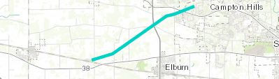
This tornado touched down just north of the intersection of Route 38 and Meredith Rd between Maple Park and Elburn. The tornado then tracked northeast into the southwest side of Campton Hills, causing mainly tree damage along its 5.9 mile path, though some damage to a grain elevator and roofing was also observed. This damage is consistent with an EF-0 rating with 80 mph winds.
Chicago NWS
Michigan Reports:
Genesee County:
An EF-2 Tornado was confirmed in Grand Blanc, MI that stretched 5.7 miles and started around 1:12 am EST on February 28th.
The tornado touched down in Creasey Bicentennial Park damaging the south pavilion and uprooting a pine tree. The tornado tracked east northeast across Westminster Cir where multiple trees were snapped, two garage doors were blown out, and a roof was partially stripped from one home. The tornado continued tracking east northeast across Porter Rd and Reid Rd where multiple limbs and trees were snapped. The peak of damage occurred at an industrial complex at the intersection of Reid and S Dort Hwy. Damage to the complex included blown out non load bearing walls and significant loss of roofing. Multiple transmission poles were also snapped along S Dort Hwy. Damaged continued into the Indian Hill neighborhood near downtown Grand Blanc where multiple large trees were downed with some of them falling onto homes along Old Bridge Rd to Stonybrook Dr. The tornado tracked east northeast across Genesee Road to Belsay Rd snapping hardwood limbs and uprooting pine trees before greater damage occurred along Moonstone Dr and Brookview Dr. Damage in these areas included more widespread tree damage and one home with a garage door blown out and a roof partially uplifted. The tornado weakened and lifted shortly after it crossed Perry Rd.
NWS Detroit/Pontiac, MI
Calhoun County:
An EF-1 Tornado was confirmed in Marshall, MI that stretched approximately 5.5 miles and started around 12:29 am EST on February 28th.
The tornado touched down just east of I-69 and north of I-94 near 16 1/2 mile road in Calhoun County. It traveled east/northeast before lifting in the vicinity of 21 1/2 mile Road and L Drive N. Hundreds of trees were snapped or uprooted along the path. The tornado heavily damged a few outbuildings and caused roof damage to a number of homes with shingles and siding torn away.
Iowa State University IEM (Iowa Environmental Mesonet)
Indiana Reports:
The current information we have for Indiana is the Highest Winds Reported.
Shelbyville 59 MPH 0300 AM 02/28
Iowa State University IEM (Iowa Environmental Mesonet)
Indianapolis 59 MPH 0217 AM 02/28
Kokomo 53 MPH 0225 AM 02/28
W. Lafayette – Purdue Univ. 49 MPH 0137 AM 02/28
Throckmorton Purdue Agricult 49 MPH 0200 AM 02/28
Lake County:
An EF-1 Tornado was confirmed in Gary/East Chicago, IN that stretched 2.19 miles (until it left land) and started around 10:15 pm CST (11:15 pm EST) on February 27th.
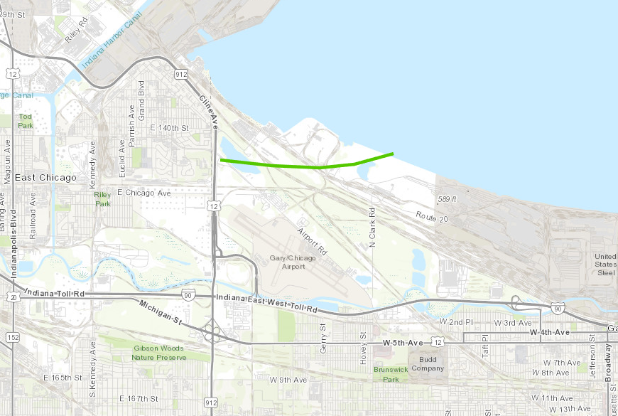
A tornado touched down near Cline Avenue and Industrial Highway just north of Gary Airport. The tornado moved eastward through a wooded industrial area and damaged multiple power poles, including snapping several that were relatively new. Snapped tree limbs were also observed along the path of the tornado. The tornado then turned east-northeast and moved offshore onto Lake Michigan.
Chicago NWS
Ohio Reports:
Franklin/Licking Counties:
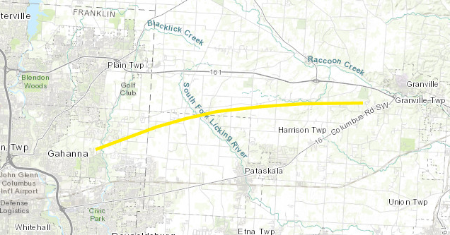
An EF-2 Tornado was confirmed in Gahanna, OH that stretched 14.1 miles and started around 5:49 am EST on February 28th.
With considerable assistance from the State of Ohio EMA, the Franklin County EMA, and the Licking County EMA, the National Weather Service in Wilmington, Ohio surveyed tornado damage from eastern Franklin into western Licking County.
Iowa State University IEM (Iowa Environmental Mesonet)
The tornado began in the Havens Corners area near the intersection of Highway 605 and Havens Corners Road, and quickly strengthened as it moved through the Havenswood neighborhood in Franklin County, producing tree and minor structural damage indicative of winds between 85 mph and 100 mph. The tornado continued to rapidly strengthen as it approached McOwen Road, where considerable tree damage was observed, with numerous stands of soft and hard wood trees snapped off completely or uprooted. A shipping container was tossed, and a home suffered extensive roof loss and the loss of one exterior wall, with debris thrown hundreds of yards downstream. In this area, winds were estimated to be around 120 mph. The tornado began weakening just a bit as it crossed into Licking County, but still produced a wide swath of tree and structural damage along its path across Graham Road SW and Highway 41. Structural damage was mainly in the form of windows blown out, destroyed barns, and minor roof removal. The tornado continued to slowly weaken as it moved east-northeast from the Jersey area toward the southwest side of Granville where it dissipated. Along this stretch, mainly tree and very minor structural damage was noted.
Montgomery/Greene Counties:
An EF-1 Tornado was confirmed in Riverside, OH, that stretched 2.42 miles and started around 4:37 am EST.
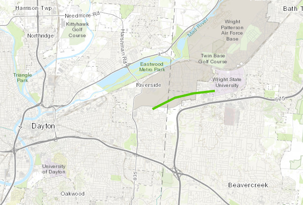
The National Weather Service in Wilmington, Ohio surveyed tornado damage from eastern Montgomery County, Ohio into Greene County, Ohio. The tornado is believed to have first developed in Montgomery County, near the dwellings located just south of Wright-Patterson Air Force base. Large, hardwood branches were broken near the intersection of Mitchell Dr and Spinning Rd. Minor tree damage continued across Airway Rd into portions of the Air Force Base.
Iowa State University IEM (Iowa Environmental Mesonet)
More notable damage was observed into Greene County, specifically at Wright-Patterson Air Force Base where a restoration hanger had minor structural damage with sheet metal ripped off. Some planes that were in the process of being restored also took damage due to flying debris. This damage was notable enough to warrant EF1 strength winds around 100 MPH. Additional damage down Loop Rd was observed from the bent guard rails and several hardwood trees broken and snapped. A few of the dwellings on the eastern side of the base took damage to the roofs as shingles were ripped off. More residential damage was observed just east of the base, with quite a bit of shingles lost on the roof of the apartment complex just behind the Meijer grocery store.
Overall, based on the damage, the tornado weakened as it traveled further eastward from this point, with mainly tree damage observed. The last bit of tree damage was found near University Blvd, just west of the Student Union associated with Wright State University.
The National Weather Service would like to thank Montgomery County EMA, Greene County EMA, and personnel at Wright-Patterson Air Force Base for their cooperation and assistance with this survey.
Clark/Madison Counties:
An EF-2 Tornado was confirmed in Springfield, OH that stretched 18.7 miles and started around 4:52 am EST on February 28th.
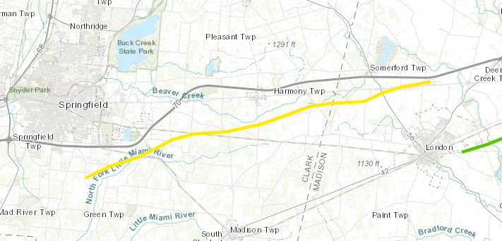
The tornado touched down south of Shawnee High School on Selma Pike where several trees were snapped. The tornado then strengthened and broadened as it moved east northeast eventually reaching EF2 intensity along Ridge Rd near Highway 41 where three homes had complete roof loss. After this, there was intermittent EF1 and EF2 damage consisting of around a dozen barns and outbuildings destroyed and more homes with complete roof loss. The tornado then continued for around 10 miles to the east northeast continuing into Madison county. The survey team was unable to complete the survey north of London as roads were still impassable so some extension of the track is still possible.
Iowa State University IEM (Iowa Environmental Mesonet)
One note about the path width of this tornado. In a couple areas, including along Hwy 41 near the Rose Hill Cemetery, the total damage path was more than a half mile wide, however, the maximum width of the tornado circulation was estimated to be around 500 yards wide. The damage pattern was extremely complex and included a significant amount of straight line wind damage to the south of the tornado track.
The NWS would like to thank both Clark County and Madison County EMA along with the state of Ohio EMA for their assistance with this survey.
Franklin County:
An EF-1 Tornado was confirmed in Hilliard, OH that stretched 2.38 miles and started around 5:26 am EST on February 28th.
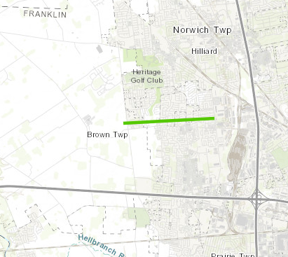
With considerable assistance from Franklin County EMA, the National Weather Service in Wilmington completed a damage survey from severe storms which occurred during the early morning of Wednesday, February 28th.
Iowa State University IEM (Iowa Environmental Mesonet)
The survey revealed that a weak tornado developed on the west side of Alton and Darby Creek Road and moved along the north side of Roberts Road through portions of the city of Hilliard. Along the path, damage was a consistent mix of snapped trees, uprooted trees, numerous instances of minor roof and siding damage. One home on Hilliard Rome Road lost part of its roof, and another home near Westbreeze Drive had an attached garage peeled away and shifted. Damage in this area was consistent with wind speeds of around 110 mph. The tornado weakened as it approached Interstate 270 and dissipated on the west side of the Interstate.
Madison County:
An EF-1 Tornado was confirmed in Wilmington, OH that stretched 8.02 miles and started around 5:14 am EST.
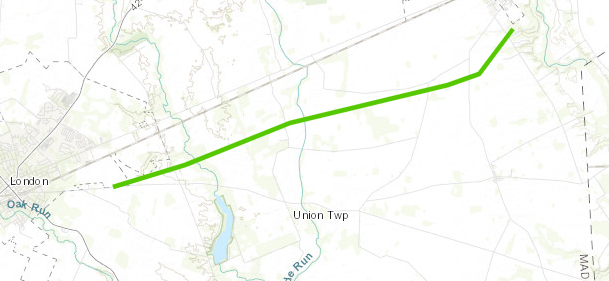
With considerable assistance from the State of Ohio EMA, and the Madison County EMA, the National Weather Service in Wilmington, OH surveyed tornado damage east of London and southwest of West Jefferson on Wednesday afternoon, in the wake of severe storms which rolled through the area earlier in the morning.
Iowa State University IEM (Iowa Environmental Mesonet)
The damage revealed that a tornado developed near State Route 665 east of London, and traversed about 8 miles to the east- northeast. While initially beginning with minor tree and structural damage, including a tipped over trailer, the tornado increased intensity as it crossed Spring Valley Road and then across Glade Run Road, peaking in intensity as it crossed Wilson Road. At this location, a home lost part of its roof, and tree damage was considerable with snapped off trunks. Damage in this area was consistent with wind speeds around 110 mph. The tornado continued across West Jefferson-Klousville Road where it shifted more abruptly northeast and weakened as it crossed Olmstead Road and dissipated.